From Alexander the Great to the Arab Empire, from the Mongol cavalry to the Ottoman army, and then to the Anglo-Russian rivalry in modern times and the encirclement by modern superpowers, almost all the top powers in human history have attempted to conquer the whole of Iran.
But the final results were remarkably consistent: either they stopped at the border mountains or they quickly withdrew after a brief occupation, and no power ever achieved long-term and complete rule.
This is no coincidence; Iran’s terrain is inherently an “empire crusher.” Today, we’ll start with its core geographical structure to thoroughly dissect the secrets of Iran’s unconquerable topography.
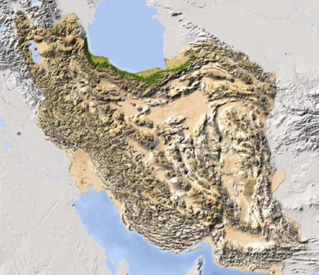
First, let’s look at the overall picture: Iran is a high-altitude fortress welded shut by mountains.
Iran has a land area of 1.64 million square kilometers, more than 70% of which is high plateau and mountainous terrain, with an average altitude of 900-1500 meters. The overall structure presents a perfect defensive pattern of being surrounded by mountains on all sides and a basin in the middle.
It is not a collection of scattered mountains, but a nested geographical defense system:
- West: Zagros Mountains, a 1500-kilometer natural Great Wall
- North: The Alborz Mountains, locking the entrance to Central Asia and the Caucasus.
- South: Makran Coast Mountains, blocking sea landings.
- East: The Suleiman Mountains and the Hindu Kush foothills isolate South Asia.
Surrounded by mountains on the outside and plateaus and deserts on the inside, any enemy that wants to enter the core area must first break through this “geographical iron cage”.
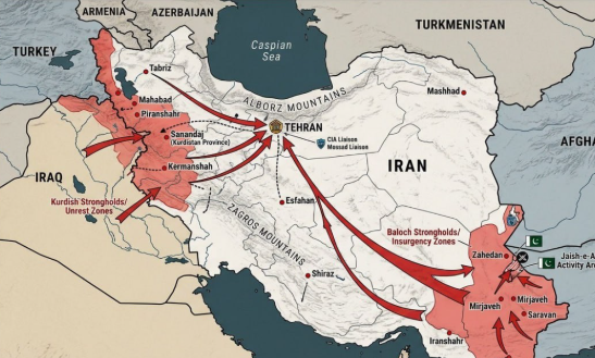
II. The First Line of Fire: The Zagros Mountains, the Invaders’ Millennial Nightmare
The Zagros Mountains are Iran’s core defensive barrier and the final destination for all Western invaders.
This mountain range has an average elevation of over 3,000 meters. It is steep and rugged with many canyons. Only a few narrow passes are passable, and all of them face the Iranian side with steep slopes.
Its military lethality is manifested in three aspects:
- Mechanized forces completely ineffective.
Tanks, heavy artillery, and armored vehicles could not be deployed in the canyon and could only be lined up in a long, straight line, becoming easy targets for anti-tank weapons. During the Iran-Iraq War, Iraq mobilized its entire national military force, but after eight years, it still failed to completely break through this mountain range.
- The supply line was cut off directly.
The mountain range is riddled with vertical ravines and lacks continuous passageways, making logistical convoys highly vulnerable to ambush when large armies traverse it. This was true for ancient cavalry, and it remains a formidable challenge for modern mechanized forces.
- The cost of an uphill attack is devastating.
Foreign enemies attacked uphill from the Mesopotamian plain, while the defenders, positioned on higher ground, were able to fight ten against one. Historically, Roman legions, Arab armies, and Ottoman armies all exhausted their main forces here.
III. The Second Barrier: The Alborz Mountains, Tehran’s Natural Shield
The Alborz Mountains in the north extend along the Caspian Sea, with the main peak, Mount Damavand, reaching 5,671 meters, making it the highest peak in the Middle East.
This mountain range directly protects the core of Iranian politics:
- Completely block the southward passage of northern forces
- The formation of an arid desert on the southern side of the mountains further increases the difficulty of the attack.
The capital, Tehran, is built on a hillside, occupying a commanding position and making it easy to defend and difficult to attack.
Historically, Russia has made several southward advances, but has always been blocked by the mountains and unable to reach the core areas of Iran.
IV. Deadly Strike in the Heartland: The Salt Flats and Deserts – A Death Trap for Invading Forces
After breaking through the mountains, the enemy will not be greeted by plains, but by a strategic dead end consisting of the Kavir Salt Desert and the Lut Desert.
The surface temperature here exceeds 70°C in summer. It is short of water, has no vegetation, and has a hard salt crust, making it difficult for vehicles to pass.
The purpose of this area:
- Dividing the territory to prevent the occupying forces from forming a unified force.
- Unable to station large armies or establish supply bases
- The defending forces can rely on oasis guerrilla warfare to continuously harass the enemy.
Even if foreign enemies manage to penetrate deep into our territory, they will be worn down by the desert and trapped in a desperate situation where they can enter but cannot hold their ground and cannot afford to lose ground.
V. Strategic Depth: Iran’s terrain is inherently advantageous against all wars of conquest.
Besides its natural defenses, Iran’s terrain has three other fatal advantages:
- The vast depth of the terrain makes a quick victory impossible.
With 1.6 million square kilometers of land, a mix of mountains and deserts, there are no shortcuts. No superpower can conquer it with a blitzkrieg.
- Fragmented terrain, making full control impossible.
Mountains, basins, and valleys isolate each other, forming natural segregated areas. Even if the occupying forces capture cities, they cannot control the mountainous areas and will never be able to eliminate resistance.
- Possessing a superior position, one has full initiative in both offense and defense.
The Iranian plateau is generally higher than the surrounding areas, allowing the defending forces to launch dive-down counterattacks while foreign enemies can only attack from above, giving Iran a complete advantage in terrain.
VI. Historical Evidence: All Great Powers Have Fallen Due to Iran’s Topography
Alexander’s Eastern Expedition: Although he conquered the Persian capital, he was unable to control the highlands, and the empire quickly collapsed.
- The Arab Empire: It only occupied the western edge, and the highland region maintained its independent culture.
- The Mongol Empire: It massacred countless cities, but due to the terrain, it could not maintain long-term control and retreated to the grasslands within a century.
- The Ottoman Empire: Multiple eastward expeditions were blocked by the Zagros Mountains, making it difficult to advance.
- The Great Anglo-Russian Rivalry: A Century-Long Struggle, Neither Side Can Conquer Whole Iran
- The Iran-Iraq War: Iraq’s eight-year bitter struggle ultimately failed to break through the mountain defenses.
Without exception, even the most powerful military will be exhausted in the face of Iran’s terrain.
VII. Conclusion: Topography is the foundation of Iran’s enduring strength over four thousand years.
Iran cannot be completely conquered, not because of the strength of its military, but because God gave it the most perfect defensive terrain.
Mountains form walls, plateaus form the base, and deserts form trenches; defenses are layered, and every step is deadly.
This is why, throughout the millennia, powerful nations have come and gone, while Iran has remained intact.
The saying “geography determines destiny” is perfectly exemplified in the case of Iran.